

Collection: Morin Collection
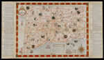
Name: Map of Connecticut : showing principal highways, with illustrations and historic references
Barcode:
Image Number:
Creator:
Publisher:
Date/Date Range Produced:
Date/Date Range Published:
Dimensions: 58.7 x 66.9
Physical Description: 1 map : col. ; 40 x 55 cm., on sheet 46 x 81 cm., folded to 23 x 11 cm
LC Call Number: G3781.A5 1935 .H452
OCLC: 55803914
Accession Number: MOR-1935-83
See Also:
Donor:
Permanent URL: