Showing 71-80 of 100966 results

Sort By:

[Chart showing America from Labrador to Brazil Fernando Bertelli]
[Chart showing America from Labrador to Brazil Fernando Bertelli]
Creator:
Date/Date Range Produced: 1565
Language:
Dimensions: 24 x 36
Printing Process:
Material Type:
Physical Description: 1 map: illustrated
LC Call Number: G9100 .B4 1565
OCLC: 57518867
Accession Number: SM-1565-5
Donor:
Image Number:


Il Disegno del discoperto della nova Franza ...
Creator:
Date/Date Range Produced: 1566
Language:
Dimensions: 28 x 41
Printing Process:
Material Type:
Physical Description: 1 map: illustrated
LC Call Number: G3300 .Z3 1566
OCLC: 57518876
Accession Number: SM-1566-2
Donor:
Image Number:


Typus Orbis Terrarum
Creator:
Title Translation: Map of the World
Publisher:
Date/Date Range Produced: 1572
Language:
Region Depicted:
Map Type:
Dimensions: 34 x 50 cm
Printing Process:
Material Type:
LC Call Number: G3200 .O7 1572
OCLC: 58436779
Accession Number: SM-1572-15
Donor:
Subjects:
Image Number:


The Rand-McNally Grammar School Geography: illustrated with diagrams, colored maps, and engravings  prepared expressly for this work
The Rand-McNally Grammar School Geography: illustrated with diagrams, colored maps, and engravings prepared expressly for this work
Publisher:
Date Produced: 1897
Language:
Dimensions: Height: 30
Physical Description: 167, 35 pages, illustrations, color maps
LC Call Number: G127 .R46 1897
OCLC: 294909886
Accession Number: OS-1897-14
Donor:
Image Number:


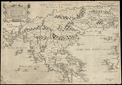
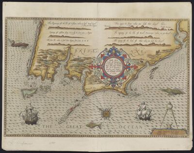
Culiacanae, Americae Regionis, Descriptio.
Creator:
Atlas Reference:
Title Translation: Description of the North American Culiacan Region: Hispaniola, Cuba, and Other Caribbean Isles
Publisher:
Date/Date Range Produced: 1579
Language:
Region Depicted:
Map Type:
Dimensions: 36 x 50 cm
Printing Process:
Material Type:
Historical Context: Ortelius created this map by himself, based upon a number of maps, including Mercator's 1569 world map, Guttierez' 1562 map of America, and Alsons de Sata Cruz' 1560 Isolario.
LC Call Number: G4414 .O7 1579
OCLC: 58436831
Accession Number: SM-1579-5
Donor:
Image Number:


Perusini agri exactissima novissimaque descriptio: auctore Egnatio Dante.
Creator:
Title Translation: A very exact and recent representation of the fields of Perugia by Egnatio Dante
Publisher:
Date/Date Range Produced: 1584
Language:
Region Depicted:
Map Type:
Dimensions: 33 x 47 cm
Printing Process:
Material Type:
Historical Context: The map is based upon Egnatio Danti's 1580 Perugia map, engraved by Mario Cartaro.
LC Call Number: G6712.P4 O7 1584
OCLC: 58436964
Accession Number: SM-1584-4
Donor:
Subjects:
Image Number:


Report of the Commissioner of the General Land Office, For the Year 1863
Date Produced: 1864
Language:
Physical Description: 1 book: 132 pages
LC Call Number: HD181.G3 1863
OCLC: 919457554
Accession Number: OS-1864-12
Donor:
Image Number:


Maine register 1822 : being a facsimile reprint of the first edition, printed 1822
Author:
Date Produced: 1972
Language:
Dimensions: Height: 15
Physical Description: 1 book: 142, [2] pages
LC Call Number: JK2830 .M3 1822
OCLC: 11165478
Accession Number: OS-1972-1
Donor:
Image Number:


The sea carde of Britayne conteining the coastes, bays, iles, and havens that lye between Rouscou and Groye verie dilligently corrected.
Creator:
Date/Date Range Produced: 1588
Language:
Dimensions: 32 x 50
Printing Process:
Material Type:
Physical Description: 1 map: colored
LC Call Number: G5833.B74 W3 1588
OCLC: 58437112
Accession Number: SM-1588-2
Donor:
Image Number: