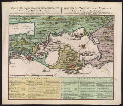
Plan du Port de la Ville et des Forteresses de Carthagene : Plan van de Haven Stadt en Kasteelen van Cartagena : représentant exactement la Vue de la Flotte Angloise, le long de la Côte, dans la Baye proche la Ville & c. suivant le dessein aporté et re
Collection: Smith Collection
Name: Plan du Port de la Ville et des Forteresses de Carthagene : Plan van de Haven Stadt en Kasteelen van Cartagena : représentant exactement la Vue de la Flotte Angloise, le long de la Côte, dans la Baye proche la Ville & c. suivant le dessein aporté et re
Barcode: 1880
Creator: Laws, William, active 1732-1747
From Atlas: No
Publishing Location: Amsterdam
Notes: Includes a numbered key indicating the locations of the Spanish and English fleets.
Date/Date Range Produced: 1741
Date/Date Range Published: 1741
Language: DutchFrench
Region Depicted: Cartagena, Colombia
Map Type: GeographicalThematic maps
Dimensions: 45 x 57 cm
Printing Process: Engraving
Printing Technique: Copper
Material Type: Paper
LC Call Number: G5294 .L3 1741
OCLC: 173665798
Accession Number: SM-1741-9
Donor: Smith
Subjects: Anglo-Spanish War, 1739-1748Austrian Succession, War of, 1740-1748Cartagena (Colombia)Cartagena (Colombia) HistoryCovens and MortierLestock, Richard, 1679?-1746Lezo, Blas de, 1687-1741NaviesOgle, Chaloner, Sir, 1681?-1750Sailing shipsVernon, Edward, 1684-1757Warships
Permenant URL: https://oshermaps.org/map/1880.0001