

Collection: Osher Collection
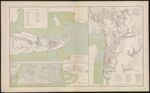
Name: Galveston, Tex. and its fortifications.
Barcode:
Image Number:
Creator:
Date Created:
Date Published:
Alternative Title: Map of siege operations against the defenses of Charleston Harbor 1863 showing batteries covering the descent upon Morris, Island, July 10 and the subsequent operations resulting in the demolition of Ft. Sumter and the capture of Ft. Wagner and Batty. Gregg September 7.; Map Port Hudson, LA. and vicinity
Notes: "Map of siege operations..." has list of engineers. No indication of whether they are map authorities or not. Should look into it. "July 10th" "September 7th, 1863" "September 27th" 1864 - Inscribed on Map; 1863 - Inscribed on Map
Permanent URL: