

Collection: Osher Collection
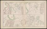
Name: Map of country in vicinity of Brown's Ferry
Barcode:
Image Number:
Creator:
Date Created:
Date Published:
Alternative Title: Map of the Battle-Field of Missionary Ridge showing the positions of Maj. Gen. Sheridan's and Brig. Gen. T. J. Wood's Divisions, Fourth Army Corps, Novbr. 23, 24 and 25, 1863, under command of Maj. Gen. Gordon Granger.; Map illustrating the positions of the Second Division, Fourth Army Corps, under the command of Maj. Gen. P. H. Sheridan, U. S. Army, in front of Chattanooga, Tenn. November 23 to 25, 1863.; Battle of Lookout Mountain, Tenn. November 24, 1863 map of the line West of Chattanooga Creek accompanying report of Maj. Gen. Carter L. Stevenson, C. S. Army commanding division and left flank, Army of the Tennessee.; Chattanooga and vicinity; Red River expedition 1864
Notes: "October 26th" "November 23rd" "November 24th" "November 25th" "November 23rd and November 25th" 1863 - Inscribed on Map; 1864 - Inscribed on Map
Permanent URL: