

Collection: Osher Collection
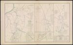
Name: Engineer Office, 10th Army Corps, Sketch No. 8. of the road between Bermuda Hundred and enemy's first line of intrenchments on the North and Petersburg on the South.
Barcode:
Image Number:
Creator:
Date Created:
Date Published:
Alternative Title: [Map 2: Position of the 4th and 23d Corps at Mud Creek, GA., 1864]; [Map 3: Position of Generals Schofield and Thomas at Noyes' Creek, GA., 1864]; Schofield crossing the Chattahoochee.; [Map 5: Positions of Generals Schofield and Hooker at Noyes' Creek, GA., 1864]; No. 3. Sketch of defensive works at Deep Bottom, VA.; Section through Dutch Gap, James River, VA.; Plan of Dutch Gap Canal and fortifications, James River, VA. Sept. 10, 1864.; No. 2. Sketch of road from pontoon-bridge at Point of Rocks to Petersburg, showing line of works captured by 18th Army Corps.; Coast of Texas and its defenses
Notes: Map 2, Map 3 and Map 5 lack inscribed titles. Bracketed titles taken from table on 3778.0001 "June 15, 1864." "September 10, 1864." 1864 - Inscribed on Map
Permanent URL: