

Collection: Osher Collection
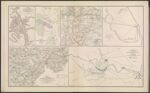
Name: Map of the Battle-Field of Wilson's Creek, MO., Aug. 10, 1861.
Barcode:
Image Number:
Creator:
Date Created:
Date Published:
Alternative Title: Battle of Cedar Mountain, VA. fought August 9th, 1862.; Map of Hanover, Henrico and part of Chesterfield Counties, VA.; Defenses of Macon, GA., 1864.; [Section of] Map of Buckingham and Appomattox Counties, VA.; Sketch showing the positions of the army on the Battle-Field of Chancellorsville, VA., May 1 to 5.
Notes: "August 10, 1861." "August 9, 1862." "December 25, 1863." "Between May 1 and May 5." 1861 - Inscribed on Map; 1865 - Inscribed on Map; 1862 - Inscribed on Map; 1864 - Inscribed on Map; 1863 - Inscribed on Map
Permanent URL: