

Collection: Osher Collection
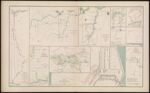
Name: Federal Point, N.C.
Barcode:
Image Number:
Creator:
Date Created:
Date Published:
Alternative Title: Fort Pemberton near Greenwood, Miss.; Topographical map of the country and vicinity of New Berne, N. C.; Plan of defensive works at Harrison's Landing, Sept. 21st, 1864.; Powder vessel exploded off Fort Fisher, N. C. Sheet No. 1; Plan, section and elevation of board loop-hole on our picket line.; No. 3. Union defensive lines, Deep Bottom, VA. chief engineer's office deprt. VA. and N.C. in the field, October 26th, 1864.; Hdqrs. Army of the Potomac, Engineer Department. Sketch showing the position West of the Weldon Railroad.; Sketch showing the positions of the redoubts and batteries of the lines of the U. S. Forces in front of Petersburg, VA. Hdqrs. Army of the Potomac, Engineer Dept., Sept. 13th, 1864.; Lookout and signal tower at Crow's Nest near Bermuda Hundred, VA.
Notes: "May, 1864." "September 21, 1864." "December 29, 1864." "February 20, 1865." "October 26, 1864." "October 8, 1864." "September 13, 1864." 1864 - Inscribed on Map; 1865 - Inscribed on Map
Permanent URL: