

Collection: Osher Collection
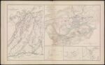
Name: Map No. 1. The Chickamauga Campaign August 16 _ September 22, 1863.
Barcode:
Image Number:
Creator:
Date Created:
Date Published:
Alternative Title: Topographical map of the approaches and defenses of Knoxville, E. Tennessee, showing the positions occupied by the United States and Confederate Forces during the siege.; [Map 3: Position of troops near Dallas, GA., May 26, 1864]; [Map 4: Positions of troops near Dallas, GA., May 27, 1864]; Sketch of roads from Gen. McCook's HDQRS. near junction of Acworth and Dallas and Marietta Roads to Acworth and Big Shanty and R.R.
Notes: Map 3 and 4 have no title inscribed on them. Bracketed titles taken from table on 3775.0001 "August 16th and September 22nd" 1863 - Inscribed on Map; Between 1863 and 1864
Permanent URL: