

Collection: Osher Collection
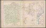
Name: Map of Spotsylvania County.
Barcode:
Image Number:
Creator:
Date Created:
Date Published:
Alternative Title: The vicinity of Hanover Junction, VA. and its defenses.; D. Sketch showing route pursued in the advance to Goldsborough, N.C., in December, 1862.; Sketch showing position of Boyd's Neck, Honey Hill, and Devaux's Neck, S. C., in December, 1864.; Sketch of Spanish Fort defenses, made during the siege
Notes: "December, 1862." "December, 1864." 1863 - Inscribed on Map; 1862 - Inscribed on Map; 1864 - Inscribed on Map
Permanent URL: