

Collection: Osher Collection
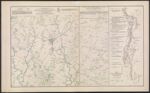
Name: Map of the Battle-Field of Gettysburg.
Barcode:
Image Number:
Creator:
Date Created:
Date Published:
Alternative Title: Map of the field of operations of Gregg's (Union) and Stuart's (Confederate) Cavalry at the Battle of Gettysburg, July 3, 1863.; Map showing the gaps in the mountains from Winter's Gap in Tenn. to Louisa in Kentucky.
Notes: H. A. Frink listed on the map. This is most likely Harry Arthur Frink, however, it is possible that this is not the case. Further research into this may be warranted. John B. Bachelder is also likely John Badger Bachelder. This also may warrant further inquiry. "Between October 21, 1868 and October 23, 1869." "July 3, 1863." "June 9, 1880." 1868 - Inscribed on Map; 1869 - Inscribed on Map; Between 1868 and 1869; 1863 - Inscribed on Map; 1880 - Inscribed on Map
Permanent URL: