↑ Parent: De Zee Atlas ofte Water-Weereld, Waer in vertoont werden alle de Zee-Kusten van het bekende des Aerd-Bodems. Seer dienstigh voor alle Schippers en Stuurlieden, Als oock voor alle Heeren en Koop-lieden. Gesneden gedruckt en uytgegeven t'Amsterdam.
Collection: Osher Collection
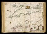
Name: Het canaal tusschen Engeland en Vrancriick. t' Amsterdam, Bij Pieter Goos.
Barcode: 7379
Image Number: 7379.0080c
Creator: Goos, Pieter, approximately 1616-1675
Date Created: 1666
Date Published: 1666
Printing Technique: Copper
Permanent URL: https://oshermaps.org/map/7379.0080c