↑ Parent: L'Atlas de la Mer, ou Monde Aquaticque, Representant toutes les Costes Maritimes de l'Univers descouvertes & cogneues. Tres necessaire & commode Pour tous Pilotes, Maistres de Navire & marchands
Collection: Smith Collection
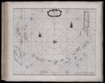
Name: Pascaert vande Caribes Eylanden
Barcode: 1751
Image Number: 1751.0123
Creator: Goos, Pieter, approximately 1616-1675
Date Created: 1667
Date Published: 1667
Title Translation: Map of the Caribbean Islands
Language: French
Region Depicted: Caribbean regionCaribbean SeaPuerto Rico
Subjects: Caribbean SeaPuerto Rico
Permanent URL: https://oshermaps.org/map/1751.0123