

Collection: Smith Collection
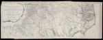
Name: An Accurate Map of North and South Carolina with Their Indian Frontiers, Shewing in a distinct manner all the Mountains, Rivers, Swamps, Marshes, Bays, Creeks, Harbours, Sandbanks and Soundings on the Coasts; with the Roads and Indian Paths; as well as The Boundary or Provincial Lines, The Several Townships and other divisions of the Land in Both the Provinces; the whole from Actual Surveys
Barcode:
Image Number:
Creator:
Date Published: May 30th, 1775
Content:
Subjects:
Full Title: An Accurate Map of North and South Carolina with Their Indian Frontiers, Shewing in a distinct manner all the Mountains, Rivers, Swamps, Marshes, Bays, Creeks, Harbours, Sandbanks and Soundings on the Coasts; with the Roads and Indian Paths; as well as The Boundary or Provincial Lines, The Several Townships and other divisions of the Land in Both the Provinces; the whole from Actual Surveys
Surveyor:
Publisher:
Language:
Region Depicted:
Dimensions: Map: H 50.5 x W 142 cm on sheet: H 55 x W 144.5 cm
Printing Process:
Printing Technique:
Permanent URL: