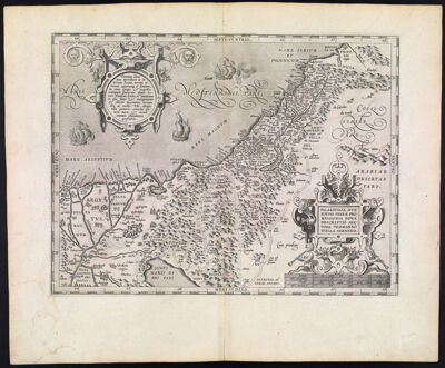
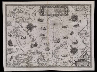
Deliniatio cartae trium navigationum per Batavos, ad Septentrionalem plagam, Norvegiae, Moscoviae, et novae Semblae, et perque fretum Weygatis Nassovicum dictum, ac huxta Groenlandiam, sub altitudine 80 graduum nec non adiacentium partium Tartariae, promontorij Tabin, freti Anian atque regionis Bargi et partis Americae versus orientem, Authore Wilhelmo Bernardo Amstelredamo expertissimo pilota.
Creator: Barentsz, Willem, approximately 1550-1597Publisher: Claesz, Cornelis, approximately 1546-1609Date/Date Range Produced: 1598
Language: DutchLatinRegion Depicted: AlaskaArctic OceanArctic regionsDavis StraitDenmarkFinlandGreenlandIcelandNorth PoleNorthwest PassageNorwayRussiaScandinaviaScotlandSwedenMap Type: GeographicalDimensions: 46 x 60 cm.
Printing Process: EngravingMaterial Type: PaperHistorical Context: A major milestone in Arctic cartography, this map illustrates details of Willem Barentsz's third voyage to this region from 1596 to 1597. Barentsz believed that a Northeastern Passage to the Pacific existed in the Arctic waters, reasoning that, because the ocean was exposed to the sun for 24 hours a day during summer, it must consist of open waters above Siberia. During the last decade of the 16th century, Barentsz made three voyages into regions surrounding the North Pole. On his third voyage, after becoming stuck on the ice and forced to winter in the Arctic, Barentsz utilized his excess time creating an elaborate and highly decorative manuscript map illustrating his observations; his map contains numerous pictures of sea monsters, ships, whales, and an island named "Polus Magnetis." Additionally the map also contains the mythical island of Frisland (Friesland) in the northwest Atlantic, the mythical Estotiland of the apocryphal 14th-century voyage by the Venetian brothers Zeno. This map became the foundation on which all further eastern Arctic exploration was predicated, making it one of the most consequential maps of its era.
LC Call Number: G3270 1598 .B3
OCLC: 79696717
Accession Number: OS-1598-5
Donor: OsherSubjects: AlaskaAnimalsArctic OceanArctic regionsBarentsz, Willem, approximately 1550-1597Cartouches, Ornamental (Decorative arts)Claesz, Cornelis, approximately 1546-1609Davis StraitDenmarkExploration and discoveryFinlandFishesGalleonsGeographical mythsGreenlandIcelandImaginary creaturesImaginary placesIndigenous peopleManners and customsMaps--Early works to 1800North PoleNorthwest PassageNorwayReindeerRussiaSailing shipsScandinaviaScotlandSea lionsSea monstersSeals (Animals)SharksSleighsSwedenVehiclesWalrusWhales

![Deliniatio cartae trium navigationum per Batavos ad Septentrionalem plagem Norvegia Moscovia et Novae Zembla et perque fretum Weygatis Nassoveam dictum acjuxta Groenlandian Sub altitudine 80 graduum nec non adiacentium partium Tartaria promotarij Tabin freti Anjun a[?] rigionis Bargi et partis Americae versus orientem Autore Wilhelmo Bernardo Amstelredam Expertisimo Pilota](https://cdn1.historyit.com/iiif/2/5f34291499c4a6.60628694/6423100e771212.19895844.jpg/full/!400,400/0/default.jpg?no_errors=1)