

Collection: Osher Map Library Collection
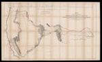
Name: Map of an Exploring Expedition to the Rocky Mountains in the year 1843. Oregon and North California in the year 1843-44
Barcode:
Image Number:
Creator:
Publishing Location:
Notes: Shows expeditionary route taken by Fremont across the American West; camps, military posts, Indian trails, areas of Indian habitation, and rivers. Inset: Profile of the route from the mouth of the Kansas to the Pacific by Capt. J.C. Fremont in 1843. Backed on canvas.
Date/Date Range Produced:
Date/Date Range Published:
Language:
Dimensions: 84 x 137
Physical Description: 1 map: colored, illustrated
Accession Number: OML-1845-33
Permanent URL: