

Collection: Osher Map Library Collection
Name: Champlain's Map of New France 1632
Barcode:
Image Number:
Creator:
Publishing Location:
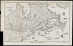
Notes: Facsimile map from State Library for Doc. History of New York, vol. 3 1850. Note: "Lith. of R.H. Pease, Albany, N.Y." Notes below neat line: "Reduced from the Original in the State Library for Dco. Hist. of N.Y. Vol. 3." "Executed by order of the Hon. Christr. Morgan, Secretary of State, Albany, N. York 1850." Map features illustrations of ships and sea monsters.
Date/Date Range Produced:
Date/Date Range Published:
Language:
Dimensions: 51 cm. x 72 cm. folds into cover 19 cm. x 9 cm.
Printing Process:
Printing Technique:
Material Type:
OCLC: 489253558
Accession Number: OML-1850-29
Permanent URL: