

Collection: Story Collection
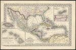
Name: Map of Mexico, Central America, and the West Indies.
Barcode:
Image Number:
Publisher:
Publishing Location:
Notes: Note below neat line: "Entered according to Act of Congress in the year 1870 by S. Augustus Mitchell, Jr. in the Clerks Office of the District Court for the Eastern District in Pennsylvania." Insets maps: "Map of the Island of Jamaica" "Map of the Sandwich Islands" "Map of the Bermuda Islands" "Map of the Panama Railroad"
Date/Date Range Produced: 1870
Language:
Region Depicted:
Dimensions: 38 x 56
Physical Description: 1 map: col. 38 x 56 cm
LC Call Number: G4410 .M5 1870
OCLC: 56625770
Accession Number: ST-1870-17
Donor:
Permanent URL: