

Collection: Osher Collection
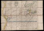
Name: A New Map of the Western Parts of Virginia, Pennsylvania, Maryland and North Carolina; Comprehending the River Ohio, and all the Rivers, which fall into it; Part of the Mississippi, the Whole of the Illinois River, Lake Erie; Part of Lake Huron, Michigan &c.
Barcode:
Image Number:
Creator:
From Atlas:
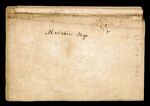
Notes: Handwritten notations in French. The copper engraved map was very likely used as a working copy by a French syndicate that invested in various land companies that dominated the region during the eighteenth century. Right-hand margin notation concerns the purchase of two million acres in the province of Maine by Secretary of War Henry Knox and William Duer. The land purchase was through Knox's political connections. The purchase had to be paid in a twelve year period so to meet their payments Knox and Duer looked for investors
Date/Date Range Produced:
Date/Date Range Published:
Language:
Region Depicted:
Map Type:
Physical Description: 1 map : colored, mounted on linen sections ; 90 x 111 cm
OCLC: 927113523
Accession Number: OS-1778-24
Donor:
Permanent URL: