

Collection: Osher Collection
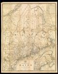
Name: Post Route Map of the state of Maine showing post offices with the intermediate distances and mail routes in operation on the 1st of December 1884.
Barcode:
Image Number:
Creator:
Alternative Title: Map of the state of Maine showing connections with the surrounding states and provinces.
Publisher:
Date/Date Range Produced:
Date/Date Range Published:
Language:
Region Depicted:
Dimensions: x
OCLC: 884813624
Accession Number: OS-1885-50
Donor:
Permanent URL: