

Collection: Story Collection
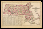
Name: Map of Massachusetts Comprising Counties, Towns, Villages, Railroads, Stations, etc.
Barcode:
Image Number:
Creator:
Date/Date Range Produced: 1871
Language:
Region Depicted:
Dimensions: 38 x 62
Notes: Notes: "H.F. Walling & O.W. Gray" "Entered according to Act of Congress in the year 1870 by Walling & Gray in the Office of the Librarian of Congress." Inset table: "Railways of Massachusetts."
Physical Description: 1 map: colored, illustrated
LC Call Number: G3764 .W3 1871
OCLC: 57227384
Accession Number: ST-1871-17
Donor:
Permanent URL: