

Collection: Osher Collection
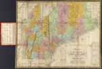
Name: Map of Maine, New Hampshire, and Vermont compiled from the latest authorities
Barcode:
Image Number:
From Atlas:
Publishing Location:
Notes: Publisher note: "Published by S. Augustus Mitchell Philadelphia. 1831." Note lower right: "J.H. Young Sc." Inset image of the "North Part of Maine." Includes statistical information about populations of each county in each state.
Alternative Title:
Brief Description:
Physical Description:
Printmaker:
Publisher:
Date/Date Range Produced:
Date/Date Range Published:
Language:
Region Depicted:
Map Type:
Dimensions: 41 x 53 cm., folded to 15 x 9 cm.
Printing Process:
Printing Technique:
Material Type:
LC Call Number: G3732 .M5 1831
OCLC: 47709534
Accession Number: OS-1831-10
Donor:
Subjects:
Permanent URL: