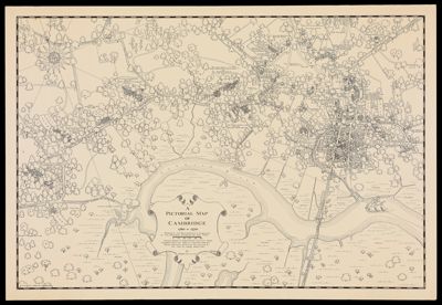
A Pictorial Map of Cambridge 1760-1770 showing the Residences & Gardens of the Principal Citizens of the Town
Collection: Osher Map Library Collection
Name: A Pictorial Map of Cambridge 1760-1770 showing the Residences & Gardens of the Principal Citizens of the Town
Barcode: 12508
Creator: Lillie, Rupert B. (Rupert Ballou), 1907-
Notes: Oriented with north toward the upper left.Shows names of buildings and property owners.Includes decorative cartouche and compass.
Date/Date Range Produced: 1949
Date/Date Range Published: 1949
Language: English
Region Depicted: Cambridge, Massachusetts
Map Type: Pictorial maps
Dimensions: 66 X 96.5 cm
LC Call Number:
OCLC:
Permenant URL: https://oshermaps.org/map/12508.0001