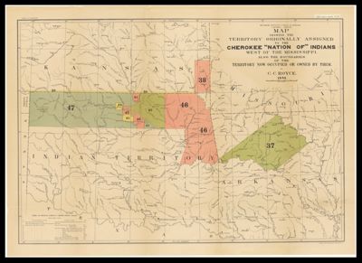
Map Showing the Territory Originally Assigned to the Cherokee "Nation of" Indians West of the Mississippi, also the boundaries of the Territory now Occupied or Owned by them, by C. C. Royce, 1884
Collection: Osher Map Library Collection
Name: Map Showing the Territory Originally Assigned to the Cherokee "Nation of" Indians West of the Mississippi, also the boundaries of the Territory now Occupied or Owned by them, by C. C. Royce, 1884
Barcode: 36150
Creator: Royce, Charles C., 1845-1923
Publishing Location: Washington D.C.
Notes: Shows parts of Kansas, Missouri, Arkansas, and the Indian Territory. Note: "N. Peters Photo-Lithographer, Washington, D.C." Notes above neat line: "Bureau of Ethnology, Fifth Annual Report, PL IX." Depicts Indian land transfer.
Publisher: Smithsonian Institution. Bureau of American Ethnology
Date/Date Range Produced: 1884
Date/Date Range Published: 1884
Language: English
Region Depicted: ArkansasIndian TerritoryKansasMissouriOklahoma
Dimensions: Map: 51 x 75 cm on sheet: 58.5 x 81.5 cm
Printing Process: Photolithograph
Material Type: Paper
LC Call Number: E51 .U55 no.5 sh.9 (HR)
OCLC: 52384472
See Also: Map of the Former Territorial Limits of the Cherokee "Nation of" Indians exhibiting the boundaries of the various Cessions of Land made by them to the Colonies and to the United States by treaty stipulations, from the beginning of their relations with the whites to the date of their removal west of the Mississippi River. by C. C. Royce, 1884
Subjects: Indigenous peoplesNative American tribesSettler-colonialism
Permenant URL: https://oshermaps.org/map/36150.0001