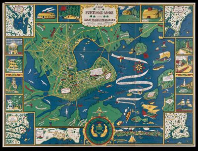
A Map of Portland Maine and some places thereabout
Collection: Osher Map Library Collection
Name: A Map of Portland Maine and some places thereabout
Barcode: 48086
Creator: Dudley, Katherine, 1900-1978
From Atlas: No
Publishing Location: Portland, ME
Notes: Illustrated hand-colored map of Portland featuring maps insets of the Kennebunks, Cape Elizabeth, Prout's Neck and Falmouth Neck (presently Portland). Also included are illustrations of historic sites. Baby Map.
Publisher: Portland Baby Hygiene & Child Welfare Association
Date/Date Range Published: 1928
Language: English
Region Depicted: Cape Elizabeth, MaineFalmouth, MaineKennebunk, MainePortland Harbor, MainePortland, MaineProuts Neck, MaineSebago Lake, Maine
Map Type: Pictorial maps
Dimensions: 74 x 99 cm
Material Type: Paper
LC Call Number:
OCLC: 451144837
See Also: A Map of Portland Maine and some places thereaboutA Map of Portland Maine and some places thereabout 1928 Copyright 1928 The Tudor Press Boston Published by Portland Baby Hygiene & Child Welfare AssociationA Map of Portland Maine and some places thereabout 1928 Copyright 1928 The Tudor Press Boston Published by Portland Baby Hygiene & Child Welfare Association
Permenant URL: https://oshermaps.org/map/48086.0001