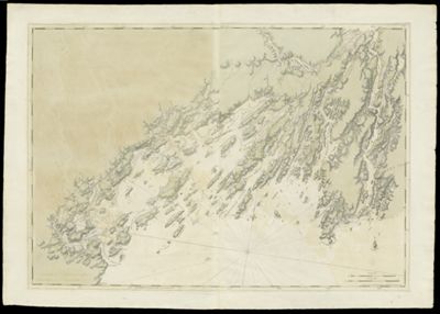
Chart of the Harbours and Rivers between Portland Point and Stage Island
Collection: Osher Collection
Name: Chart of the Harbours and Rivers between Portland Point and Stage Island
Barcode: 818
Creator: Des Barres, Joseph F. W. (Joseph Frederick Wallet), 1729-1824
From Atlas: No
Publishing Location: London
Notes: Note: "Publish'd According to Act of Parliament July 1776, by J.F.W. Des Barres Esqr." Map shows Casco Bay including islands, bays and harbors: Portland Sound; Falmouth Harbour; Ram Island; Banej's Island; Houfe Island; Peaks Island; Little Hog Island; Great Hog Island; Hussey's Sound; Long Island; Makey's Island; Presumscok Cove; Broad Cove; Green Islands; Jewels Island; Halfway Road; Jewels Island; Crotch Island; Great Jebieg Island; Brocon Cave; Broad Sound; Drunker's Island; Little John's Island; Cousin's Island; Majea's Island; Little Whale Boat Island; Great Whale Boat Island; Mark Islands; Mericonig Sound; Mericonig Neck; Mericonig Harbour; Balies Island; The Silver Islands; Goose Islands; Magout Bay; Birch Island; Middle Bay; Little Jebascadiggin Island; Pond Island; Ram Island; Rugged Island; Mark Island; Cohauk Bay; Great Jebascadiggin Island; New Meadows Harbour; Merrymeeting Bay; Long Beach; Parkers Island; Segadahock River; Rodger's Bay; Stage Island; Segevin Island; Cape Smallpoint; Smallpoint Harbour; Flagg Island; Long Ledge.
Publisher: Des Barres, Joseph F. W. (Joseph Frederick Wallet), 1729-1824
Surveyor: Holland, Samuel, 1728-1801
Date/Date Range Published: Jul 1776
Language: English
Region Depicted: Casco Bay, MaineCumberland County, MaineLincoln County, MaineMaine coastMerrymeeting Bay, MaineSagadahoc County, Maine
Map Type: GeographicalNautical charts
Dimensions: Chart: 74.5 x 106.5 cm on sheet: 85 x 120 cm
Printing Process: Engraving
Printing Technique: Copper
Material Type: Paper
LC Call Number:
OCLC:
See Also: A Chart of Delawar Bay.Chart of Coast from Pemaquid Point to Owl's Head Bay [sheet 1 of 2]Chart of Coast from Pemaquid Point to Owl's Head Bay [sheet 2 of 2]Chart of Coast from Pemaquid Point to Owls Head BayChart of Falmouth HarbourChart of Falmouth HarbourChart of Grand Manan IslandChart of Passamaquody BayChart of Penobscot Bay (Upper Part)Chart of the Coast from Burntcoal Island to Skulock PointChart of the Coast from Cape Elizabeth to Musketo IslandChart of the Coast from Cape Elizabeth to Musketo Island Chart of the Coast from Musketo Island to Skuttock PointChart of the Coast Goldsborough to Moose Harbor [Sheet 2 of 3]Chart of the Coast Goldsborough to Moose Harbor [Sheet 3 of 3]Chart of the Coast Goldsborough to Moose Harbor. [Sheet 1 of 3]Chart of the Coast Goldsborough to Moose HarbourChart of the Coast of GeorgiaChart of the Entrance into Penobscot BayChart of the Harbours and Rivers between Portland Point and Stage IslandCharts of the Coast and Harbors of New England [...] [Title page]Coast from Newbury to Cape ElizabethNotes Biographical and Bibliographical on The Atlantic NeptuneThe Coast of New England.Views: (I) Mechios River near the Mills. (II) A Sketch of Mechios Mills[Boston Harbor Chart Des Barres] [facsimile][Coast of Maine - from Spurwink River to Moose Point] [or, from Musketo Island to Cape Elizabeth, including Kennebec River] [facsimile][Coast of Maine - Two Views of Wolves Islands at Entrance of Passamaquoddy Bay][Coast of Maine]
Donor: Osher
Subjects: American Revolution, 1775-1783Maine--MapsMaps--Early works to 1800
Permenant URL: https://oshermaps.org/map/818.0001