Collection: Osher Collection
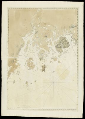
Name: Chart of the Coast from Musketo Island to Skuttock Point
Barcode: 820
Creator: Des Barres, Joseph F. W. (Joseph Frederick Wallet), 1729-1824
From Atlas: No
Publishing Location: London
Notes: Note lower right: "Publish'd according to Act April 24, 1776 by J.F. W. Des Barres Esqr." Map includes bays, islands, and other landmarks: Woodenball Rock; Seal Rock; Ragged Arse Island; Matinicus Island; Metinick Island; Musketo Island; Musketo Harbour; Moose Point; Muscle Ledge Islands; Owl's Head Islands; Owl's Head Bay; Clamb Cove; Southern Harbour; Northern Fox Island; Southern Fox Island; Stroud's Island; Meguanticook Harbour; Penobscot Bay; Belfast Bay; Penobscot River; Castine Fort; Bucks Harbour; Isle Haut Bay; Southwest Harbour; Isle Haut; Deer Island; Harbour Island; Milk Rock; Burnt Coat Island; Pound Island; Ship Island; Thrump Cape; Robison Island; Hangman's Neck; Long Island; Great Blue Hill Bay; Mount Desart or Union River; Skillinges River; Tanton River; Flanders Bay; Porcupine Islands; Ironbound Island; Egg Rock; Musquas; Shuttock Point; Lamb Island; Lobster Cove; Frenchman's Bay; East Point; Bear Island; Suttons Island; Great Cranberry Island; Bakers Island; Bass Island; Mount Desart Island; Cross Island; Black Island; Little Duck Island.
Publisher: Des Barres, Joseph F. W. (Joseph Frederick Wallet), 1729-1824
Surveyor: Holland, Samuel, 1728-1801
Date/Date Range Published: Apr 24th, 1776
Language: English
Region Depicted: Frenchman's BayHancock County, MaineKnox County, MaineMaine coastMount Desert Island, MainePenobscot County, MaineWaldo County, Maine
Map Type: GeographicalNautical charts
Dimensions: Chart: 103.5 x 73 cm on sheet: 120 x 84.5 cm
Printing Process: Engraving
Printing Technique: Copper
Material Type: Paper
LC Call Number:
OCLC:
See Also: A Chart of Delawar Bay.Chart of Coast from Pemaquid Point to Owl's Head Bay [sheet 1 of 2]Chart of Coast from Pemaquid Point to Owl's Head Bay [sheet 2 of 2]Chart of Coast from Pemaquid Point to Owls Head BayChart of Falmouth HarbourChart of Falmouth HarbourChart of Falmouth HarbourChart of Grand Manan IslandChart of Passamaquody BayChart of Penobscot Bay (Upper Part)Chart of the Coast from Burntcoal Island to Skulock PointChart of the Coast from Cape Elizabeth to Musketo Island Chart of the Coast from Cape Elizabeth to Musketo IslandChart of the Coast Goldsborough to Moose Harbor [Sheet 2 of 3]Chart of the Coast Goldsborough to Moose Harbor [Sheet 3 of 3]Chart of the Coast Goldsborough to Moose Harbor. [Sheet 1 of 3]Chart of the Coast Goldsborough to Moose HarbourChart of the Coast of GeorgiaChart of the Entrance into Penobscot BayChart of the Harbours and Rivers between Portland Point and Stage IslandChart of the Harbours and Rivers between Portland Point and Stage IslandCharts of the Coast and Harbors of New England [...] [Title page]Coast from Newbury to Cape ElizabethNotes Biographical and Bibliographical on The Atlantic NeptuneNotes Biographical and Bibliographical on The Atlantic Neptune [Front cover]The Coast of New England.Views: (I) Mechios River near the Mills. (II) A Sketch of Mechios Mills[Boston Harbor Chart Des Barres] [facsimile][Coast of Maine - Two Views of Wolves Islands at Entrance of Passamaquoddy Bay]
Donor: Osher
Subjects: American Revolution, 1775-1783Maine--MapsMaps--Early works to 1800
Permenant URL: https://oshermaps.org/map/820.0001