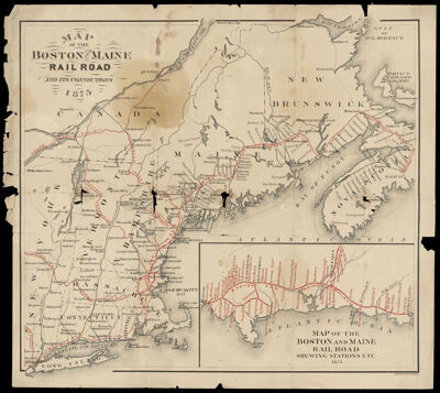
Map of the Boston and Maine Railroad and its Connections 1875
Collection: Osher Collection
Name: Map of the Boston and Maine Railroad and its Connections 1875
Barcode: 1152
Creator: Anonymous / Unknown Author
From Atlas: No
Notes: Inset: Map of the Boston and Maine Railroad shewing stations, etc. 1875.Verso has doodles of a star, a tree, a goat, and what looks like half of the American flag.
Publisher: Forbes and Co.
Date/Date Range Produced: 1875
Date/Date Range Published: 1875
Language: English
Region Depicted: Bay of FundyConnecticutGulf of Saint LawrenceMaineMassachusettsNew BrunswickNew HampshireNew York (State)Nova ScotiaPrince Edward Island, CanadaRhode IslandSaint Lawrence RiverVermont
Map Type: Railroad maps
Dimensions: H 34.8 x W 39.4 cm
LC Call Number: G3761.P3 F67 1875
OCLC: 55154106
Donor: Osher
Subjects: New BrunswickNew EnglandNew York (State)Nova Scotia (Canada)Prince Edward IslandRailroadsRivers and lakes
Permenant URL: https://oshermaps.org/map/1152.0001; 1152.0002