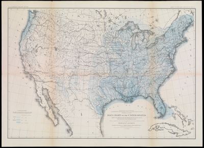
Department of the Interior U.S. Geographical and Geological Survey of the Rocky Mountain Region. J.W. Powell in charge. Rain Chart of the United States. Showing by isohyteal lines the distribution of the mean annual precipitation in rain and melted snow. This is a copy of the chart constructed for the Smithsonian Institution in 1868 Charles A. Schott except that the lines are slightly modified in Texas and New Mexico. The base chart was engraved for the Statistical Atlas of the United States. Julius Bien, Lithographer.
Collection: Osher Collection
Name: Department of the Interior U.S. Geographical and Geological Survey of the Rocky Mountain Region. J.W. Powell in charge. Rain Chart of the United States. Showing by isohyteal lines the distribution of the mean annual precipitation in rain and melted snow. This is a copy of the chart constructed for the Smithsonian Institution in 1868 Charles A. Schott except that the lines are slightly modified in Texas and New Mexico. The base chart was engraved for the Statistical Atlas of the United States. Julius Bien, Lithographer.
Barcode: 1166
Creator: Powell, John Wesley, 1834-1902Schott, Charles A. (Charles Anthony), 1826-1901
Publishing Location: Washington D.C.
Notes: This map is copy 1, identical to OS-1878-28 (copy 2).Top of map: "To accompany report on the lands of the arid region."
Date/Date Range Produced: 1868 - 1878
Language: English
Dimensions: 50 cm. x 71 cm. on sheet 56 cm. x 77 cm.
LC Call Number:
OCLC: 52778229
Donor: Osher
Permenant URL: https://oshermaps.org/map/1166.0001