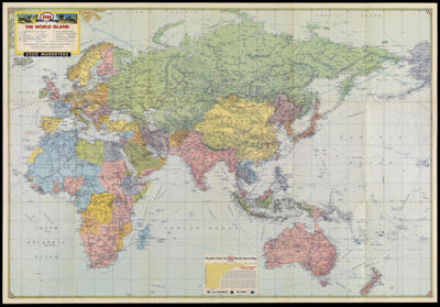
Esso War Map II featuring The World Island, Fortress Europe
Collection: Osher Collection
Name: Esso War Map II featuring The World Island, Fortress Europe
Barcode: 1541
Publisher: Esso MarketersGeneral Drafting Company
Publishing Location: New York
Notes: Map shows railroads, roads, pipelines, steamship distances, and international boundaries as of March 11, 1938.Boundary changes in Central Europe since 1938.Verso: The world island [i.e. Eastern hemisphere] Miller cylindrical projection
Date/Date Range Produced: 1943
Date/Date Range Published: 1943
Language: English
Dimensions: 58 x 84 cm. folded to 20 x 14 cm.
LC Call Number: G5670 1943 .G4
OCLC: 4358695
Accession Number: OS-1944-2
Donor: Osher
Subjects: World War, 1939-1945
Permenant URL: https://oshermaps.org/map/1541.0001