Chart of the Interior Part of North America Demonstrating the Very Great Probability of an Inland Navigation from Hudsons Bay to the West Coast
Collection: Osher Collection
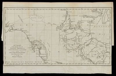
Name: Chart of the Interior Part of North America Demonstrating the Very Great Probability of an Inland Navigation from Hudsons Bay to the West Coast
Barcode: 872
Creator: Array
Printmaker: T. Woodman & H. Mutlow
From Atlas: No
Notes: Note in lower left corner: "J. Haywood delr. St. Martin's Church Yard." Note in lower right corner: "Woodman & Mutlow, Sculpt. Russel Court"
Publisher: Haywood, James
Date/Date Range Produced: 1790
Date/Date Range Published: 1790
Language: English
Region Depicted: CanadaHudson BayJames Bay, Nunavut, CanadaSlave River Valley, Canada
Map Type: Geographical
Dimensions: 24 x 45 cm. on sheet 27 x 47 cm.
Printing Process: Engraving
Printing Technique: Copper
Material Type: Paper
LC Call Number:
OCLC: 52087888
Donor: Osher
Subjects: CanadaExploration and discoveryLakesMaps--Early works to 1800RiversT. Woodman & H. MutlowWaterways
Permenant URL: https://oshermaps.org/map/872.0001