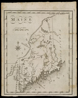
Maine
Collection: Osher Collection
Name: Maine
Barcode: 892
Creator: Scott, J. T. (Joseph T.)
From Atlas: No
Notes: From: The United States GazetteerMap shows rivers, lakes, capes and bays: Cape Neddock; Saco Bay; Casco Bay; Cold River; Saco River; Salmon Falls; Androscoggin River; Sagadahoc River; Kenebec River; Umbagog Lake; Connecticut River; West Chandiere; East Chandiere; Chandiere River; Agamun tic P.; Portage; Sebaim Lake; Kersisongar Lake; Wiguda River; Ourangabena Lake; Spey River; St. Johns River; Passamaquoddy River; St. Croix River; Chenesbec Lake; Panaunke Lake; Penobscot River; Machias Bay; Mount Desert Island; Frenchman's Bay; Island au Haut; Penobscot Bay; Manhegin Island.
Date/Date Range Produced: 1795
Date/Date Range Published: 1795
Language: English
Region Depicted: MaineNew Hampshire
Map Type: Geographical
Dimensions: H 21 x W 17 cm
Printing Process: Engraving
Printing Technique: Copper
Material Type: Paper
LC Call Number:
OCLC:
Donor: Osher
Subjects: MaineMaine--MapsMaps--Early works to 1800Rivers and lakes
Permenant URL: https://oshermaps.org/map/892.0001