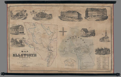
Map of the town of Ellsworth, Hancock Co., Maine from the actual survey by D.S. Osborn
Collection: Osher Map Library Collection
Name: Map of the town of Ellsworth, Hancock Co., Maine from the actual survey by D.S. Osborn
Barcode: 54257
From Atlas: No
Publishing Location: Philadelphia
Notes: Images around border: Residence of J.M. Hale; Whiting's Hall, Whiting's Block; Residence of Col. Jarvis; Residence of T. Robinson; Block: Hancock Bank, Z. Smith, G.W. Brown, J.W. & T.D. Jones, Half & Eaton, J.S. Races Office "A Fox Cheap Cash Store," A Wiswell Office, Calvin G. Peck, E.B. Reynolds, G.N. Black & Co., Eastern Freeman, Austin & Chute, Corn & Flour, Printing Office, Jadeane Bank; Jones' Steam Hill; Orthodox Church; Residence of Col. Black.Inset of Fall's Village and Ellsworth.Contains the Ellsworth Business Directory.Property map with owners names listed.
Publisher: Woodford, E. M.
Surveyor: Osborn, D. S.
Date/Date Range Produced: 1855
Date/Date Range Published: 1855
Language: English
Region Depicted: Ellsworth, MaineHancock County, MaineMaine
Map Type: City mapsGeographicalHistorical mapsWall maps
Dimensions: 83 x 129 cm
Printing Process: Lithograph
LC Call Number: G3734.E5 1855 O8
OCLC: 1198165946
Subjects: Ellsworth, MaineHancock County (Me.)Historic buildingsMaine--MapsTownsVillages
Permenant URL: https://oshermaps.org/map/54257.0001