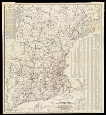
The New England Commercial and Route Survey showing all Postoffices, Railroads, Electric Roads in operation and proposed, Good Roads, Population (showing latest Massachusetts census) and a comprehensive Distance Table.
Collection: Osher Collection
Name: The New England Commercial and Route Survey showing all Postoffices, Railroads, Electric Roads in operation and proposed, Good Roads, Population (showing latest Massachusetts census) and a comprehensive Distance Table.
Barcode: 1335
Notes: Notes: "Compiled and engraved from Government Surveys and Original Information." "Copyright 1905 by S.F. Blanchard & Co., Worcester, Mass. All rights reserved"Includes: Index to towns and population, U.S. census 1900 and Mass. state census, 1905Table: Distances by rail, generally travelled routes. Includes distances between the larger cities and towns of New EnglandElectric railway routes and proposed routes printed in orange
Publisher: Home Educator Company
Date/Date Range Produced: 1905
Date/Date Range Published: 1905
Language: English
Dimensions: 88 cm. x 80 cm. folded into covers 24 cm. x 12 cm.
LC Call Number: G3721.P3 1905 H65
OCLC: 56626361
Donor: Osher
Permenant URL: https://oshermaps.org/map/1335.0001