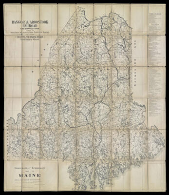
Bangor & Aroostook Railroad and Connections, showing the Industrial and Agricultural Territory reached including Hunting and Fishing Region Northern Maine : Sportsman's and Lumberman's Map of Maine Compiled from plans of State Assessors
Collection: Osher Collection
Name: Bangor & Aroostook Railroad and Connections, showing the Industrial and Agricultural Territory reached including Hunting and Fishing Region Northern Maine : Sportsman's and Lumberman's Map of Maine Compiled from plans of State Assessors
Barcode: 1350
Creator: Array
Printmaker: Array
From Atlas: No
Publishing Location: Boston (Mass.)
Notes: Notes: "Drawn by R.E. Mullaney" and "Issued by the Eastern Improvement Company, Bangor, Me." and "Copyright by R.M. Mason. 1906." Map is sectioned and mounted on linen.
Publisher: Eastern Improvement Company
Date/Date Range Produced: 1906
Date/Date Range Published: 1906
Language: English
Region Depicted: Aroostook County, MaineFranklin County, MaineHancock County, MaineOxford County, MainePenobscot County, MainePiscataquis County, MaineSomerset County, MaineWaldo County, Maine
Map Type: Road maps
Dimensions: 123 x 106 cm.
Material Type: Paper
LC Call Number: G3731.E63 1906 E3 c.1
OCLC: 183191477
Donor: Osher
Subjects: Aroostook County, MaineBangor and Aroostook Railroad CompanyFranklin County, MaineHancock County, MaineLakesMaineOxford County, MainePenobscot County, MainePiscataquis County, MaineRailroadsRiversRoad mapsSomerset County, MaineWaldo County, MaineWashington County, Maine
Permenant URL: https://oshermaps.org/map/1350.0001; 1350.0002