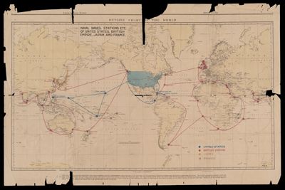
Outline chart of the world
Collection: Carpenter Collection
Name: Outline chart of the world
Barcode: 52327
Publisher: Chicago TribuneUnited States. Hydrographic Office.
Date/Date Range Produced: 1928
Date/Date Range Published: 1928
Language: English
Region Depicted: World
Dimensions: 53 x 81 cm
Notes: 5th ed., October 1927Chicago Sunday Tribune, November 25, 1928"Published Oct., 1922 at the Hydrographic Office under the authority of the Secretary of the Navy." Text ad bottom explains, :Why the United States rejected the Anglo-French BNaval Compromise.Map shows Naval bases of United States, British Empire, Japan and France
Accession Number: CCA,D,M-1928-152
Donor: Carpenter
Permenant URL: https://oshermaps.org/map/52327.0001