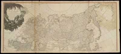
Asia and Its Islands according to D'Anville; Divided into Empires, Kingdoms, States, Regions, &c. with The European Possesions and Settlements In The East Indies and An Exact Delineation of all the Discoveries made in the Eastern Parts By The English under Capt. Cook.
Collection: Howard Collection
Name:
Asia and Its Islands according to D'Anville; Divided into Empires, Kingdoms, States, Regions, &c. with The European Possesions and Settlements In The East Indies and An Exact Delineation of all the Discoveries made in the Eastern Parts By The English under Capt. Cook.
Barcode: 3220
Creator: Laurie & WhittleSayer, Robert, 1725-1794
Publisher: Laurie & Whittle
Date/Date Range Produced: May 12th, 1794
Date/Date Range Published: May 12th, 1794
Language: English
Region Depicted: AsiaCentral AsiaManchuria regionMongoliaRussiaSiberia, Russia
Map Type: GeographicalPolitical maps
Dimensions:
102 x 120 cm
Printing Process: Engraving
Printing Technique: Copper
Material Type: Paper
LC Call Number:
OCLC:
Donor: Howard
Permenant URL: https://oshermaps.org/map/3220.0001