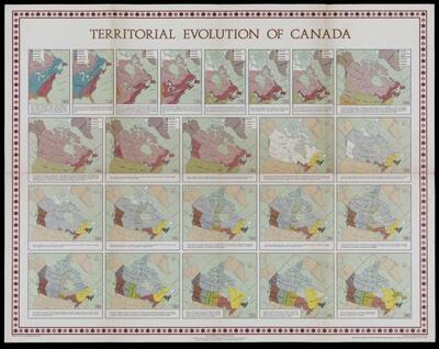
Territorial Evolution of Canada
Collection: Osher Map Library Collection
Name: Territorial Evolution of Canada
Barcode: 4889
Creator: Canada. Geographical Branch
From Atlas: Yes
Publishing Location: Ottawa, Canada
Notes: Notes below neat line: "Printed by Surveys and Mapping Branch, 1967." "These maps are to be published in the Atlas of Canada. Issued as a supplement to the October, 1967 issue of the Canadian Geographic Journal." "Produced by the Geographical Branch." "Copies may be obtained from the Map Distribution Office, Department of Energy, Mines and Resources, Ottawa, Canada."
Atlas Reference: Atlas of Canada
Subjects: Array
Publisher: Canada. Geographical Branch
Date/Date Range Produced: 1967
Date/Date Range Published: 1967
Language: English
Region Depicted: Canada
Map Type: Boundary mapsHistorical mapsPolitical maps
Dimensions: 57 x 72 cm.
Material Type: Paper
LC Call Number: G3401.F3 1967 .C3
OCLC: 5568126
Accession Number: OML-1967-8
Permenant URL: https://oshermaps.org/map/4889.0001