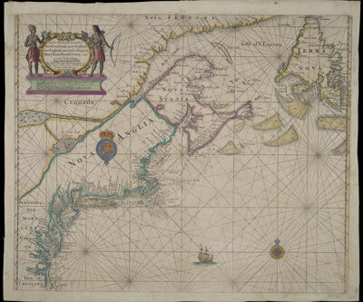
A New Chart of the Sea Coast of Newfound land, new Scotland, new England, new Jersey, Virginia, Maryland, Pennsylvania, and part of Carolina. By Iohn Thornton Hydrographer at the Signe of England, Scotland, and Ireland in the Minories London.
Collection: Osher Collection
Name: A New Chart of the Sea Coast of Newfound land, new Scotland, new England, new Jersey, Virginia, Maryland, Pennsylvania, and part of Carolina. By Iohn Thornton Hydrographer at the Signe of England, Scotland, and Ireland in the Minories London.
Barcode: 516
Creator: Thornton, John, 1641-1708
From Atlas: Yes
Notes: 2nd edition. Originally published by John Thornton who was associated with John Seller and later entered into partnership with Fisher. This second state reflects the new owners, Fisher and Mount.
Publisher: Fisher, W. (William), -1692Mount I, Richard (1654-1722)
Date/Date Range Produced: 1685
Date/Date Range Published: 1685
Language: English
Region Depicted: Atlantic StatesConnecticutDelawareEastern CanadaLong Island, New YorkMaineMaritime ProvincesMarylandMassachusettsMiddle Atlantic StatesNew EnglandNew HampshireNew JerseyNew York (State)Newfoundland and LabradorNorth CarolinaNova ScotiaOntarioPennsylvaniaRhode IslandSaint Lawrence RiverVirginia
Map Type: Nautical charts
Dimensions: H 46.8 x W 56.9 cm
Printing Process: Engraving
Printing Technique: Copper
Material Type: Paper
LC Call Number:
OCLC: 856535051
Donor: Osher
Permenant URL: https://oshermaps.org/map/516.0001