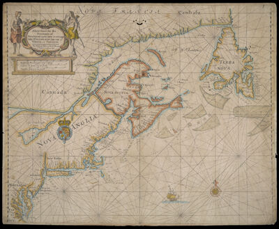
A New Chart for the Seacoasts of Newfound Land New Scotland New England New Jarsey with Virginia and Maryland. By William Fisher and Rich:d Mount at ye Postern on Tower Hill
Collection: Osher Collection
Name: A New Chart for the Seacoasts of Newfound Land New Scotland New England New Jarsey with Virginia and Maryland. By William Fisher and Rich:d Mount at ye Postern on Tower Hill
Barcode: 517
Creator: Fisher, W. (William), -1692
From Atlas: Yes
Notes: Originally published by John Thornton who was associated with John Seller and later entered into partnership with Fisher. This second state reflects the new owners, Fisher and Mount.
Publisher: Mount I, Richard (1654-1722)Thornton, John, 1641-1708
Date/Date Range Published: 1687
Language: EnglishLatin
Region Depicted: ConnecticutDelawareEastern CanadaMaineMaritime ProvincesMarylandMassachusettsMiddle Atlantic StatesNew EnglandNew HampshireNew JerseyNew York (State)Newfoundland and LabradorNova ScotiaOntarioPennsylvaniaRhode IslandVermontVirginia
Map Type: Nautical charts
Dimensions: H 43.9 x W 54.2 cm
Printing Process: Engraving
Printing Technique: Copper
Material Type: Paper
LC Call Number:
OCLC: 856535051
Donor: Osher
Permenant URL: https://oshermaps.org/map/517.0001