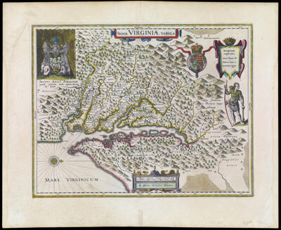
Nova Virginiae Tabvla
Collection: Osher Collection
Name: Nova Virginiae Tabvla
Barcode: 413
Creator: Gryp, Dirck
From Atlas: Yes
Publishing Location: Amsterdam
Notes: Based on John Smith's map of the Chesapeake Bay region. Verso: Text in French.
Publisher: Blaeu, Willem Janszoon, 1571-1638
Date/Date Range Produced: 1640
Date/Date Range Published: 1640
Language: FrenchLatin
Region Depicted: Chesapeake BayChesapeake Bay RegionMarylandVirginia
Map Type: Geographical
Dimensions: H 48.9 x W 59.8 cm
Printing Process: Engraving
Printing Technique: Copper
Material Type: Paper
LC Call Number: G3880 1640 .G7
OCLC: 70260080
Donor: Osher
Subjects: Blaeu, Willem Janszoon, 1571-1638Cartouches, Ornamental (Decorative arts)Chesapeake Bay (Md. and Va.)Chesapeake Bay Region (Md. and Va.)Clothing and dressDevices (Heraldry)EnglandEthnologyHeaddressesHeraldryHides and skinsIndians of North AmericaMaps--Early works to 1800MarylandNative AmericansScrollworkVirginiaWeapons
Permenant URL: https://oshermaps.org/map/413.0001; 413.0002