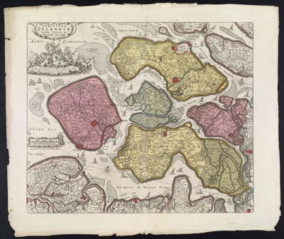
Comitatus Zelandiae Novissima Delineatio per Nicolaum Visscher Nun[c] apud Pet: Schenk Iun
Collection: Smith Collection
Name: Comitatus Zelandiae Novissima Delineatio per Nicolaum Visscher Nun[c] apud Pet: Schenk Iun
Barcode: 1849
Creator: Visscher, Nicolaes, 1618-1679
From Atlas: Yes
Publishing Location: Amsterdam
Notes: Note left side: "cum Privil. : Ordin. General Belgii Foederati". Map was published in 1636 by Claus Janz. Visscher and in the atlas Belgium sive Germania inferior in 1637. In 1726 Peter Schenk purchased the map plates from Visscher's widow, Elizabeth Verseyl and published the map after this date. Shadow of Claus Janz. Visscher's imprint on lower right corner of map.
Atlas Reference: Belgium sive Germania inferior
Subjects: Array
Publisher: Schenk, Petrus, 1693-1775
Date/Date Range Produced: 1726
Date/Date Range Published: 1726
Language: DutchLatin
Region Depicted: Zeeland, Netherlands
Map Type: GeographicalPolitical maps
Dimensions: 47 x 55 cm
Printing Process: Etching
Printing Technique: Copper
Material Type: Paper
LC Call Number: GA921 .V5 1726
OCLC: 173314793
Accession Number: SM-1726-3
Donor: Smith
Permenant URL: https://oshermaps.org/map/1849.0001