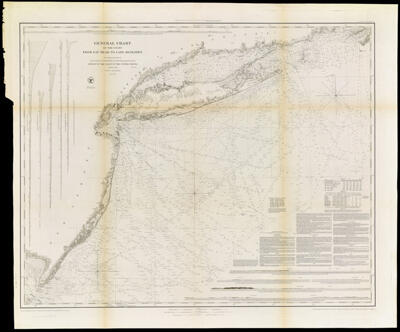
General Chart of the Coast from Gay Head to Cape Henlopen : From a Trigonometrical Survey under the direction of F.R. Hassler and A.D. Bache Superintendents of the Survey of the Coast of the United States Published in 1852
Collection: Osher Map Library Collection
Name: General Chart of the Coast from Gay Head to Cape Henlopen : From a Trigonometrical Survey under the direction of F.R. Hassler and A.D. Bache Superintendents of the Survey of the Coast of the United States Published in 1852
Barcode: 3345
Publishing Location: Washington D.C.
Notes: Electrotype No. 2
Note above neat line: "Presented under the authority of an Act of Congress of the United States of June 3d. 1844 & by direction of the Treasury Dapartrment. A.D Bache Superintendent Coast Survey." "Electrotype Copy No. 2 by G. Mathiot U.S.C.S."
Notes below the neat line: "Reduction for Engraving by J. Farley Asst., C. Mahon, J.J. Ricketts & J. Lambert Draughtsmen. Views by J. Farley Asst." "Topography engraved by E. Dankworth& O.A. Lawson, Lettering by John Knight, Views by O.A. Lawson. Soundings by J. Knight & W. Smith. Sections by G. McCoy & O.A. Lawson."
Relief shown by hachures. Depths shown by soundings.
Includes text, charts of tides and lighthouses, 6 views and 5 section diagrams.
Date/Date Range Produced: 1852
Date/Date Range Published: 1852
Language: English
Dimensions: 75 x 94
OCLC: 30464570
Accession Number: OML-1852-9
Permenant URL: https://oshermaps.org/map/3345.0001