Map of Pacific Ocean Mercators Projection compiled by H.E.C. Robinson P.T.Y.L.T.D
Collection: Osher Map Library Collection
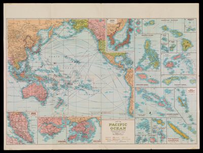
Name: Map of Pacific Ocean Mercators Projection compiled by H.E.C. Robinson P.T.Y.L.T.D
Barcode: 4887
Publishing Location: Sydney
Notes: 25 inset maps including Japan, Hawaii, Singapore, Hong Kong and many Pacific Islands.Shows naval bases, shipping routes, and railways.Uses colors to indicate British, Japanese, USA, French, Netherlands, and other countries' ownership.
Date/Date Range Produced: 1945
Date/Date Range Published: 1945
Language: English
Region Depicted: Pacific Ocean
Dimensions: 52 x 65 cm. on sheet 77 x 102 cm., folds to 26 x 20 cm.
LC Call Number: G9230 .H4
OCLC: 54622458
Permenant URL: https://oshermaps.org/map/4887.0001; 4887.0002