Phillips' Map of Northern Maine East of the Allagash

Collection: Osher Map Library Collection

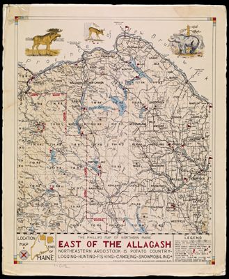
Name: Phillips' Map of Northern Maine East of the Allagash

Barcode: 12012

Creator: Augustus D. Phillips & Son

Publishing Location: Northeast Harbor, ME

Notes: Note under title: Northeastern Aroostook is Potato Country-Logging-Hunitng-Fishing-Canoeing-Snowmobiling

Date/Date Range Produced: 1970

Date/Date Range Published: 1970

Language: English

Region Depicted: Maine

Dimensions: 58 x 48 cm

OCLC: 34073689

Accession Number: OML-1970-29

Donor: Eastman

Permenant URL: https://oshermaps.org/map/12012.0001