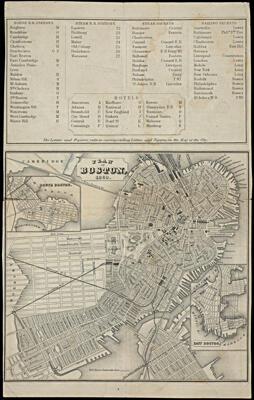
Plan of Boston, 1860.
Collection: Osher Map Library Collection
Name: Plan of Boston, 1860.
Barcode: 14248
Creator: Smith, Knight and Tappan
Date/Date Range Produced: 1860
Date/Date Range Published: 1860
Language: English
Dimensions: 13 x 13 cm and 11 x 13 cm on sheet 21 x 14 cm
Notes: Inset maps of East Boston and South Boston.
Verso: "Map of Boston and Vicinity 1860"
Includes index of railroad stations, steam and sailing packets, hotels and places of interest.
OCLC: 586080656
Accession Number: OML-1860-29
Permenant URL: https://oshermaps.org/map/14248.0001; 14248.0002