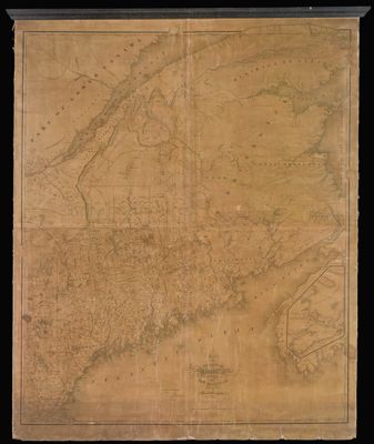
Map of the State of Maine with the Province of New Brunswick
Collection: Osher Map Library Collection
Name: Map of the State of Maine with the Province of New Brunswick
Barcode: 13314
Creator: Greenleaf, Moses, 1777-1834
From Atlas: No
Publishing Location: Philadelphia
Notes: Includes inset with image of Gulf of St. Lawrence, Bay of Fundy, New Brunswick and Nova Scotia
Publisher: Dankworth, Frederick, approximately 1804-Young, J. H. (James Hamilton)
Date/Date Range Produced: 1844
Date/Date Range Published: 1844
Language: English
Region Depicted: Bay of FundyGulf of Saint LawrenceMaineNew BrunswickNova ScotiaSaint Lawrence River
Map Type: Wall maps
Dimensions: 197 x 133 cm
LC Call Number:
OCLC:
Donor: Green
Subjects: CountiesGreenleaf, Moses, 1777 -1834Gulf of Saint LawrenceMaineNew BrunswickNova Scotia (Canada)Rivers and lakesWhite Mountains (N.H. and Me.)
Permenant URL: https://oshermaps.org/map/13314.0001