Collection: Osher Map Library Collection
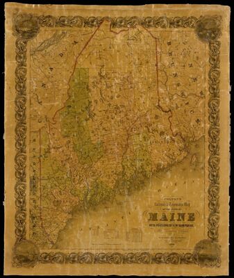
Name: Colton's Railroad & Township Map of the state of Maine with portions of New Hampshire, New Brunswick & Canada.
Barcode:
Creator:
Publisher:
Publishing Location:
Notes:
Date/Date Range Produced:
Date/Date Range Published:
Language:
Region Depicted:
Dimensions: 86 x 69 cm
LC Call Number: G3731.P3 1853.C6
OCLC: 777210732
Accession Number: OML-1853-29
Donor:
Permenant URL: