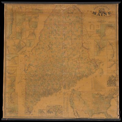
Map of the State of Maine from surveys made by the United States Coast Survey from the British and American Boundary Commissioners Survey 1862
Collection: Osher Map Library Collection
Name: Map of the State of Maine from surveys made by the United States Coast Survey from the British and American Boundary Commissioners Survey 1862
Barcode: 13278
Creator: Walling, Henry Francis, 1825-1888
From Atlas: No
Publishing Location: Washington D.C.
Notes: Copy 3Contains images of Maine towns around the edges: Presque Isle; Calais; Houlton; Bangor; Ellsworth; Eastport; Machias; White Mountains; Belfast; Saco & Biddefor; Auburn & Lewiston; Rockland; Thomaston; Brunswick; Portland; Bath; Waldoboro; Augusta; Gardiner; Waterville; Hallowell; Wiscasset; Skowhegan; Paris Hill; Farmington; Fryeburg; Dover & Foxcroft; as well as: the World and The United States.Includes data from the 1860 census of both Maine by county and each individual state; distances between towns; heights of the White Mountains
Publisher: Chace, J.
Date/Date Range Produced: 1862
Date/Date Range Published: 1862
Language: English
Region Depicted: MaineUnited StatesWorld
Map Type: Wall maps
Dimensions: 87 x 122 cm
LC Call Number:
OCLC:
Subjects: BoundariesCensusMaineMountainsRivers and lakesWorld
Permenant URL: https://oshermaps.org/map/13278.0001