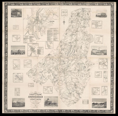
A Topographical Map of Androscoggin County, Maine from actual surveys by J.Q. Page, Civil. Eng. and others ; J. Chace, Jr. publishers, Phila. and Portland, Me
Collection: Osher Map Library Collection
Name: A Topographical Map of Androscoggin County, Maine from actual surveys by J.Q. Page, Civil. Eng. and others ; J. Chace, Jr. publishers, Phila. and Portland, Me
Barcode: 13282
Creator: Chace, J.Page, J. Q.
Publishing Location: Philadelphia
Notes: Inset maps and illustrations at margins: "Lewiston with business directories," "Mechanic Falls with business directory," "North Turner," "North Livermore," "Maine Hotel, Lewiston Falls, James F. Davis," "Livermore Falls," "East Auburn," "A.C. Denison & Co.'s Paper Mill, Mechanic Falls," "Sabattus Ville," "Greene Corner," "Barkers Mills," "Little River Village," "Lisbon Village," "Lewiston Falls, Me.," "County buildings, Auburn, Me.," "Poland Village," "West Durham," "Residence of Capt. John Lombard Wales, Androscoggin," "West Auburn," "Turner Village," "Minot Corner," "West Minot," "Maine State Seminary, Lewiston Falls," "South West Bend," "North Auburn cards," "Elm House, Auburn, Wm. S. Young, proprietor."
Publisher: Chace, J.
Date/Date Range Produced: 1858
Date/Date Range Published: 1858
Language: English
Region Depicted: Androscoggin County, Maine
Map Type: Wall maps
Dimensions: H 152 x W 152 cm
LC Call Number:
OCLC: 263871884
Subjects: Androscoggin County (Me.)Maine
Permenant URL: https://oshermaps.org/map/13282.0001